Tags
Air-raid shelter, Barclays Bank, Carmarthen Road, Chimneys, Co-operative, Fforestfach, Gwenfrwdd buildings, library, Molly's, Post box, Post Office, Premier, Senior Service advertisement, Spar, Street lighting, Sub-postmaster Mr William Williams
Photo used with the kind permission of Maureen Davies.
(Click on photo for a larger view)

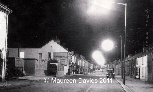
From the left side: Is edge of the CO-OPERATIVE building (a small supermarket by today’s standards) , part of the archway is shown which gave access to the rear of the shop. On the right of this building, before the railings, slightly back, was a door that opened on to stairs that led up to the library above the shop.
The next building was a relic of WWII, the windowless communal air-raid shelter with six air vents at the front. This structure is one of my earliest memories as a 2 or 3 year old child around 1968/9, looking up from my pushchair alongside the steel bus stop and seeing this tall grey building, which seemed out of place in this small village, as there wasn’t a door or window to be seen on the front of this building. Latter on after the building’s demolition, the area became the site of Barclays Bank.
Next the red post box marked GR (King George V – 1910-1936). Onwards to the building with an advertisement on its side, extension and 1st floor light on is the much used Post Office. The buildings purpose is a giveaway, as the large square poster says:
“FFOREST FACH POST OFFICE
GREETING CARDS . STATIONARY & CONFECTIONARY
Senior Service
the best cigarette
——— at its best”
There are a couple of other signs bolted on to the decorative corner bricks of the front side of the Post Office; I think the bottom circular sign says “CAPSTAN cigarettes”. The front of the building is made of poll stone with brick finishing, enclosing upper windows. The ground floor is wooden fronted with a pull-down blind which has been left out. The previous sub-postmaster was Mr William Williams until the tragic event which took place on 15th November 1957. The building’s purpose changed from a Post Office to a small supermarket in the 1990s, then became a Spar and now in 2011 a Premier, both are convenience stores. The Post Office has moved left next door.
The following building along looks like it houses a business due to the frontage and sign, as a couple walk by holding hands.
The next is called Gwenfrwdd buildings which housed a butcher and grocer business run by A. Payne in the early 1950s. At some point Mary Ann Charles then owned the building, succeeded by her children Edwin and Lillian. Lillian eventually gave up part of the business and Edwin and his wife May continued until, they sold out to Jack Phillips and his wife Margaret. For the last few years, the building is used as a ladies fashion boutique called Molly’s, previously a smaller business resided at 852 Carmarthen Road. Two vehicles can be seen outside, an early mini and a minivan.
Carmarthen Road in this photo viewed eastwards towards Cwmdu, is a reasonably straight road and then bends left just before the entrance to Kings Head Road. The road view is empty of passing traffic and only a few cars are seen, unlike today 2011. Virtually all the buildings have chimneys, as coal was the fuel of the day. *All the houses on the right-hand side were demolished in a major road widening, part of “The Carmarthen Road Clearance” in the late 1980s and early 1990s.
*(the land from Station Road to Bryn Road is now occupied by Ty Dewi Sant – a sheltered housing complex)

You must be logged in to post a comment.