Tags
1964, 1970s, Brick Works, Brickyard Road, Cadle or Caereithin, Cambrian paper, Carmarthen Road, cobbler's shop, Cockett, Cwmbwrla, Cwmdu, Fforestfach, Kensitas cigarettes, Lyons Cakes, milk bottles, OS 1879 map, OS 1899 map, OS 1916 map, OS 1940 map, OS 1948-50 map, poll stone, road windening, stone built house, Street lighting
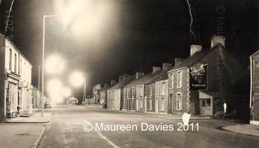
On the left is the brick-built number *774 Carmarthen Road, a shop with a pull down blind over the door and windows, the shop’s name is unreadable and the windows have a few signs at the top, outside there are two signs,
Lyons Cakes and underneath an oblong Kensitas cigarettes, outside the doorway there is a metal gate for added security, the sign underneath the large windows is unreadable, at the bottom of the drain pipe are several empty glass pint milk bottles, ready for collection and possible replacement by the local milkman.
Photo used with the kind permission of Maureen Davies. (Click on photo for a larger view)
The houses on the left-hand side of the road, have only a single parked car near by, this side of the road houses were largely untouched by the Carmarthen road widening in Fforestfach during the 1990s.
On the other side of the road near the Mile End, the houses nearest the pavement have long since been demolished through the road improvements.
The terrace houses to the left of the tall warehouse building, all five are shown on the OS 1899 map.
There are seven houses to the right of the entrance to Cwmdu Estate 743,745-747,749-751,753 & 755 (first shown on the OS map 1940)
and to the left of the of nine houses, all have lost their front walls (in photo) and gardens during road widening.
The next right, eight houses are stone built with some exterior renderings have been applied, Some of the houses show four pots on their chimneys,
indicating four fireplaces two up and two down. The house numbers are probably 757,759,761,-763,765,767,769,771, on the right is a Poll stone fronted house possibly 773 and has a large sign advertising Swan Matches “The smoker’s match”, with a lean-To property underneath and on the left of Brickyard Road is a small cobbler’s shop (possibly the last in the village), first shown properly on OS 1940 map. On the far right of the photo the stone built house (only partially seen) has also gone, which could have been the original building shown on the 1879 OS map.
The first reference to Brick Works at the rear of Brickyard Road was in the Swansea Cambrian paper of 1815. Brick Works are seen from the OS maps of 1879 – OS map of 1948-50 possibly as late as 1995 but not named.
Brickyard Road wasn’t named untill the OS map of 1916. I remember the road surface in the 1970s as a very rough mixture of stone and mud, with large potholes which filled with water when it rained.
*The shop, number 774 and houses 772 and 770 are in small terrace and first seen on the OS 1916 map, 772 has railings in front of the house and 770 look as though they’ve taken them down, possibly due to the house being on a corner or rusting away.
If you have anymore information about this image or factual information in and around Fforestfach, Cwmbwrla, Cockett, Cadle, Caereithin, or Gendros please leave a comment (on the right underneath heading) or for more detail contact me through my email address on www.fforestfachhistory.com.

The shop on the left was taken over by the Lodge family late 1950’s. John Lodge, son of the owners went, I think, to Penlan Academy for the Sons of Gentlefolk. Ian Bates
The house edge seen on the right edge of the photograph, opposite the cobbler’s, was no 775 where my pal Peter Holborow lived. 1955 Electoral Register shows Frederick John Holborow and Mary E. Holborow living there. I have taken the spelling of Holborow from that register.