The Tivoli Cinema Cwmbwrla, Swansea

Tags

, , , , , , , , , , , , , , , , , , , , , , ,

The word “Cwmbwrla which means valley of Bwrlais”, Bwrlais Brook runs down along the right hand side of Heol-y-Gors, to the rear of Boots Opticians and Trainer BMW franchise. Cwmbwrla was known for its boundary of the Borough of Swansea for many years until the extension of 1918, when many other surrounding areas were also included within Swansea.

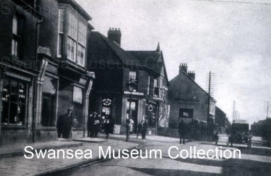
This photo is originally from a postcard taken in 1927. A smaller cropped area has been enlarged on this image which kindly came from Swansea Museum. The Tivoli cinema also known as Tivoli Hall was opened in (*1) 1913 at the junction of Carmarthen Road and Heol-y-Gors. In the (*1) orginal postcard photo, several chimneys are seen to the buildings left. They could be from Blackvale Works (copper) and Swansea Works (Tin), these factories were situated roughly between Trainer’s Mini car sales franchise and where Wicks DIY store are today.
The position of the cinema today, took me a while to be sure of after using a number of old books, photos and maps. The front of the building faced Libanus Chapel 1906. After a fire on 21st January 2012 the upper floor was demolished, along with roof damage of its earlier outgrown Old Libanus (1867) Welsh Baptist chapel next door. To the building’s left in the photo is Heol-y-Gors and left again would have been the Mission Hall today named Gorse Mission (F.1904) and built 1926. On the right of the Tivoli are a number of shops including the Cwmbwrla Post Office, then next door was (*2) P.W Hussey in 1910 and (*3) Star Supplies in 1965 on the end nearest the picture house. Running right in alignment with both, the nearest building oppersite and the cinema was Cae Bricks. This old road is now only a shadow of original size and can be seen from the rear of The Three Sisters pub, (a name taken from old Cwmfelin works where the tall chimneys were seen from miles around). The road carries on towards Manselton till it meets up with David Street and Robert Street.

Picture House

Cwmbwrla's Early Cinema

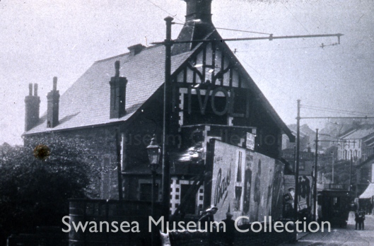
In front next to the low capped wall, I’m puzzled by the metal looking shelter under the streetlight, if anybody who knows the answer could you let me know? The image looks like it’s been taken in the late afternoon judging from the shadows, near the three flat capped men and poster of the Bass beer advertisement. The tall street posts and their long arms holding the electric cables fed the tramway (*4) 1900-1937 (earlier, from 1874–1900 the tramways were horse-drawn), then came the faster and more efficient transport vehicle, the bus. The tramway, advertising “Bovril” (a salty meat extract drink, developed in the 1870s) on its roof, the tram has reached its terminus at Cwmbwrla and Middle Road can be seen climbing upwards towards Gendros. On the far right you can see a shop front with its canvas blind pulled down, this would give shade in the summer and would also help protect perishable goods. The cinema looks like it had a previous use, with the brick-up window on its left side, possibly a Welfare Hall built for community events and deteriorated, then began a new lease of life as a popular cinema. This happened with many other Welfare Halls around the area such as Fforestfach. If you know the building previous function, could you let me know? Latter on (*5) Morsmith Motors car showroom was sited here.

The building was demolished in 1960s, the area can be seen in a photo book by the (*6) Evening Post 1967, in preparation for the new dual carriageway and roundabout. The building is mentioned in OS maps from 1899 as “hall” and even 1972-95 a building is still shown in the same spot, I didn’t rely on latter maps after 1966 as they no longer label the building!

Source
(*1) Swansea in old picture postcards, J.R. Alban City Archivist, Swansea I100 1985 ISBN 9028890928
(*2) South Wales Evening Post Swansea Memory Lane p159 1999 ISBN 1859831737
(*3) South Wales Evening Post Swansea Memory Lane p74 1999 ISBN 1859831737
(*4) Swansea in old picture postcards, J.R. Alban City Archivist, Swansea I52 1985 ISBN 9028890928
(*5) The Story of Swansea’s Districts and Villages V2, C1, p46 Norman Lewis Thomas (volume 1 – abridged volume 2) 1969 ISBN 978-0-9501065-0-2
(*6) South Wales Evening Post Images of Swansea p57 1998 ISBN 1859831346

1879 OS MAP – shows Blackvale Works (copper) and Swansea Works (Tin), just a little higher than Babell Chapel (Welsh Calvinistic Methodist).
1936-38 OS map – shows works to the rear which are no longer named.

Carmarthen Road near Fforestfach Cross – 1964 Street lighting check (2 of 2)

Tags

, , , , , , , , , , , , , , ,

Photo used with the kind permission of Maureen Davies.
(Click on photo for a larger view)

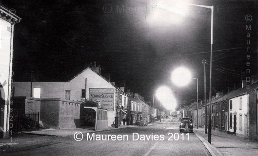
From the left side: Is edge of the CO-OPERATIVE building (a small supermarket by today’s standards) , part of the archway is shown which gave access to the rear of the shop. On the right of this building, before the railings, slightly back, was a door that opened on to stairs that led up to the library above the shop.

The next building was a relic of WWII, the windowless communal air-raid shelter with six air vents at the front. This structure is one of my earliest memories as a 2 or 3 year old child around 1968/9, looking up from my pushchair alongside the steel bus stop and seeing this tall grey building, which seemed out of place in this small village, as there wasn’t a door or window to be seen on the front of this building. Latter on after the building’s demolition, the area became the site of Barclays Bank.

Next the red post box marked GR (King George V – 1910-1936). Onwards to the building with an advertisement on its side, extension and 1st floor light on is the much used Post Office. The buildings purpose is a giveaway, as the large square poster says:
“FFOREST FACH POST OFFICE
GREETING CARDS . STATIONARY & CONFECTIONARY
Senior Service
the best cigarette
——— at its best”
There are a couple of other signs bolted on to the decorative corner bricks of the front side of the Post Office; I think the bottom circular sign says “CAPSTAN cigarettes”. The front of the building is made of poll stone with brick finishing, enclosing upper windows. The ground floor is wooden fronted with a pull-down blind which has been left out. The previous sub-postmaster was Mr William Williams until the tragic event which took place on 15th November 1957. The building’s purpose changed from a Post Office to a small supermarket in the 1990s, then became a Spar and now in 2011 a Premier, both are convenience stores. The Post Office has moved left next door.

The following building along looks like it houses a business due to the frontage and sign, as a couple walk by holding hands.
The next is called Gwenfrwdd buildings which housed a butcher and grocer business run by A. Payne in the early 1950s. At some point Mary Ann Charles then owned the building, succeeded by her children Edwin and Lillian. Lillian eventually gave up part of the business and Edwin and his wife May continued until, they sold out to Jack Phillips and his wife Margaret. For the last few years, the building is used as a ladies fashion boutique called Molly’s, previously a smaller business resided at 852 Carmarthen Road. Two vehicles can be seen outside, an early mini and a minivan.

Carmarthen Road in this photo viewed eastwards towards Cwmdu, is a reasonably straight road and then bends left just before the entrance to Kings Head Road. The road view is empty of passing traffic and only a few cars are seen, unlike today 2011. Virtually all the buildings have chimneys, as coal was the fuel of the day. *All the houses on the right-hand side were demolished in a major road widening, part of “The Carmarthen Road Clearance” in the late 1980s and early 1990s.
*(the land from Station Road to Bryn Road is now occupied by Ty Dewi Sant – a sheltered housing complex)

Carmarthen Road,Near Brickyard Road entrance, Street lighting check of 1964 (1 of 2)

Tags

, , , , , , , , , , , , , , , , , , , , , , ,

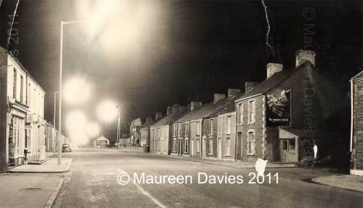
On the left is the brick-built number *774 Carmarthen Road, a shop with a pull down blind over the door and windows, the shop’s name is unreadable and the windows have a few signs at the top, outside there are two signs,
Lyons Cakes and underneath an oblong Kensitas cigarettes, outside the doorway there is a metal gate for added security, the sign underneath the large windows is unreadable, at the bottom of the drain pipe are several empty glass pint milk bottles, ready for collection and possible replacement by the local milkman.

Photo used with the kind permission of Maureen Davies.                                                  (Click on photo for a larger view)
The houses on the left-hand side of the road, have only a single parked car near by, this side of the road houses were largely untouched by the Carmarthen road widening in Fforestfach during the 1990s.

On the other side of the road near the Mile End, the houses nearest the pavement have long since been demolished through the road improvements.
The terrace houses to the left of the tall warehouse building, all five are shown on the OS 1899 map.

There are seven houses to the right of the entrance to Cwmdu Estate 743,745-747,749-751,753 & 755 (first shown on the OS map 1940)
and to the left of the of nine houses, all have lost their front walls (in photo) and gardens during road widening.

The next right,  eight houses are stone built with some exterior renderings have been applied, Some of the houses show four pots on their chimneys,
indicating four fireplaces two up and two down. The house numbers are probably 757,759,761,-763,765,767,769,771, on the right is a Poll stone fronted house possibly 773 and has a large sign advertising Swan Matches “The smoker’s match”, with a lean-To property underneath and on the left of Brickyard Road is a small cobbler’s shop (possibly the last in the village),  first shown properly on OS 1940 map.  On the far right of the photo the stone built house (only partially seen) has also gone, which could have been the original building shown on the 1879 OS map.

The first reference to Brick Works at the rear of Brickyard Road was in the Swansea Cambrian paper of 1815.  Brick Works are seen from the OS maps of 1879 – OS map of 1948-50 possibly as late as 1995 but not named.
Brickyard Road wasn’t named untill the OS map of 1916. I remember the road surface in the 1970s as a very rough mixture of stone and mud, with large potholes which filled with water when it rained.

*The shop, number 774 and houses 772 and 770 are in small terrace and first seen on the OS 1916 map, 772 has railings in front of the house and 770 look as though they’ve taken them down, possibly due to the house being on a corner or rusting away.

If you have anymore information about this image or factual information in and around Fforestfach, Cwmbwrla, Cockett, Cadle, Caereithin, or Gendros please leave a comment (on the right underneath heading) or for more detail contact me through my email address on www.fforestfachhistory.com.

FFORESTFACH CROSS

Tags

, , , , , , , , , , , , , , , , , , , , , , , , , , , , ,

Hello, this blog is meant to work alongside the www.fforestfachhistory.com website, the purpose of the blog is a more efficient way of posting images and information on a regular basis which will hopefully achieve a better sense of two-way communication.

Thanks all.

Early photo of Fforestfach Cross looking East towards Swansea, around the 1930s, used with Swansea Museum’s kind permission. (Click image for larger view).

Taken from the middle of Carmarthen Road, roughly at todays’ 2011 traffic lights in the middle of the left-hand lane and parallel to the current Marquis car park, either lunch time or late afternoon judging by the school children.

From the left: A shoe shop run by Dan Thomas during the 1920s. Next, the double fronted Hudson’s bakery shop, with a flat capped man waiting in the doorway and the bakery at the rear, with library and reading rooms on the first floor. The male crowd standing round a man with a newspaper and near a street lamp could be either gas or electric?  On the opposite side of Ravenhill Road two children stand looking towards the camera.  The *red bricked London House, with the possibly of Mr William Davies in the doorway who ran an ironmonger and stationers during the 1920s and related to the Hocknell family. The building behind with the small spire is Jerusalem Chapel, Methodist (1910).  Next, the double chimney of the Co-operative building with two chimneys and eight fireplaces, built around 1910, during the 1930s the library was moved to the first floor of this large building. The building to the right, is poll stone fronted and a Hosiery business run by W. Williams and later went on to become the longstanding Post Office, which then moved next door. You can see the telephone poles running alongside the buildings on both sides of the road towards Swansea.  On the right hand side of Carmarthen Road the terrace houses were built prior to the 1879 OS map.  The car looks like a late 1920’s Model T Ford.  The nearest pair of shadows are of the Marquis Arms roof dormers, the building had a possible link to the Marquis of Worcester and the pub looks as if it was first leased in 1843.
*The matt red bricks looks like the same that was used in building of Gendros School (established 1897).

If you have anymore information about this image or factual information in and around Fforestfach, Cwmbwrla, Cockett, Cadle Caereithin or Gendros please leave a comment (on the right underneath heading) or for more detail contact me through my email address on www.fforestfachhistory.com.